Accomplishments
The CVJV partnership has earned an impressive record of accomplishment since its inception in 1988, and is making great progress towards meeting the objectives identified in its 2020 Implementation Plan.
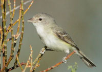 Bell’s Vireo
By Matthew Reiter and Catherine Hickey
Point Blue Conservation Science
Mark Reynolds
The Nature Conservancy

Water is a vital resource for wildlife and people in the Central Valley of California but is becoming increasingly scarce and supplies are unreliable; problems potentially exacerbated by climate change. Finding solutions to water management challenges that will optimize among competing interests (wetland management, human consumption, agriculture, etc.) will require innovative strategies and partnerships. At the most basic level, conservation solutions will require knowing where the water is now and where it will be in the future.
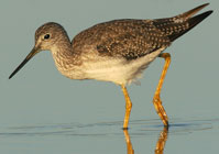
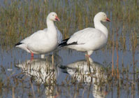
The availability of water during the fall migration period (July 15 – October 31) in the Central Valley is considered a limiting factor for waterbird populations (ducks, geese, shorebirds, colonial waterbirds, and marsh birds). Consequently, for the Central Valley Joint Venture, understanding the patterns of water distribution is essential to conservation planning, particularly for wetland dependent species, however no analytic assessment of these patterns exist. In 2012, we initiated a project using freely available satellite imagery to identify where the water was during the fall migration period over a 12-year time frame (2000-2011) and how much the amount of water changes through the season and among years in the Central Valley.
Overall our data suggest that the majority of the surface water in the Central Valley during July through October is concentrated near the Delta. This is not too surprising as this is the nexus of the Sacramento and San Joaquin river systems. Wetlands in the Grassland Ecological Area, centered near Los Banos, have shown increasing water on the landscape earlier in fall over the last 12 years. Our assessment also suggests that the proportion of managed wetlands that are “open” water and thus habitat for shorebirds, in particular, may be overestimated in current planning models and should be adjusted to reflect the conditions on the ground. Our fine scale water distribution data can help guide decisions on conservation and management actions at basin, sub-basin and even parcel levels during this highly dynamic period of water availability.
These initial results enable us to learn even more about the dynamics of water in the Central Valley. For example, we can use our spatial information on water to develop models to predict water occurrence and to reveal the factors that are most important to water distribution. Such predictive models can help quantify the impacts of climate change scenarios on water resources. Also, we can use these water data in combination with bird monitoring data to better understand the influence of water availability on the distribution of waterbirds during migration and how that may be affected by a changing climate. New analyses of water and birds will help identify areas that could be targeted for easements, acquisitions, and management to promote conservation of all waterbirds.
Although this work will especially help with the management of wetland dependent bird species, we also suspect this detailed assessment of the distribution of surface water would be of interest to those managing fish populations throughout the Sacramento River and San Joaquin River ecosystems as well. Knowing where the water is and where it will be in the future is essential to maximize the potential co-benefits of water management (birds, fish, and agriculture) and to identify optimal strategies for managing water across the entire Central Valley during a time of rapid environmental change.
For more information contact: Matt Reiter; mreiter@pointblue.org; 760-417-9997
The CVJV partnership has earned an impressive record of accomplishment since its inception in 1988, and is making great progress towards meeting the objectives identified in its 2020 Implementation Plan.
Follow these links to learn about some of the important bird conservation work happening in California's Central Valley.